The Real World in Computational Space
Can Geography Improve Your Health?
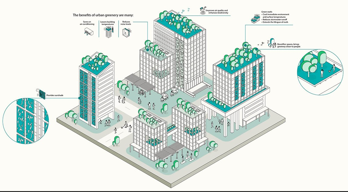
a GIX application
Active Health & Nature
-
Access to green space improves physical activity
Parks, gardens, waterfronts, and nature corridors invite walking, cycling, and outdoor play, which encourage healthier lifestyles and reduce sedentary behaviors.
-
Exposure to nature benefits mental well-being
Natural environments — including trees, waterways and shaded open areas — can reduce stress and improve mood, creating more restorative and enjoyable urban places.
-
Green and blue spaces support climate resilience
By cooling urban heat islands and managing stormwater, these spaces make cities safer and more comfortable — indirectly enhancing outdoor comfort and long-term health.
-
Inclusive nature access promotes equitable health outcomes
Planning parks, pathways, and green networks within walking distance of all communities helps ensure that everyone can benefit from nature-based activity spaces.
see URA webpage for more details.
Health is Spatial
Where You Live Shapes How You Live.
-

Access to parks influences exercise
People who live within walking distance of parks and green corridors are more likely to engage in regular physical activity. When recreational spaces are unevenly distributed, entire communities experience different health outcomes.
-

Walkable streets affect obesity rates
Neighborhoods designed with connected sidewalks, mixed land use, and safe crossings encourage daily walking and active transport. In contrast, car-dependent environments reduce incidental movement and are associated with higher obesity risk.
-

Air quality varies by neighborhood
Exposure to air pollution is not evenly distributed across a city, often affecting communities near highways or industrial areas more severely. Long-term differences in air quality contribute to disparities in respiratory and cardiovascular health outcomes.
Blue Space
Rivers, lakes, coastlines
Blue spaces include oceans, rivers, lakes, and coastal systems that regulate climate, shape landscapes, and sustain human settlements. Understanding blue space requires analyzing hydrological processes, environmental risk, and the spatial dynamics of water across scales. These systems are central to resilience, sustainability, and global environmental change.
Green Space
Parks and forests
Green spaces include forests, agricultural landscapes, urban vegetation, and ecological corridors that support biodiversity and human well-being. These environments shape microclimates, carbon cycles, and spatial inequalities across regions. Studying green space combines spatial data, environmental monitoring, and geographic theory to understand land-use change and ecosystem resilience.
How GIS Supports Health
Measure. Map. Identify.
-
Measure park accessibility
GIS calculates walking distance and travel time to parks, green corridors, and recreational facilities. This helps planners identify underserved neighborhoods and prioritize equitable access to open space.
-
Map walking networks
Spatial analysis evaluates sidewalk connectivity, street density, and pedestrian safety features across the city. These insights support the design of more walkable environments that encourage daily physical activity.
-
Identify health inequality patterns
By layering demographic, environmental, and health outcome data, GIS reveals spatial disparities in exposure and risk. Policymakers can then target interventions where they are needed most.
GIX in Action
Health statistics
Health statistics provide structured data on disease patterns, demographic risk factors, and population health trends across regions. By integrating spatial dimensions into these datasets, we can identify geographic inequalities, emerging hotspots, and areas requiring targeted intervention.
Mobility tracking
Mobility tracking captures how people move through urban environments using aggregated location or transport data. Analyzing movement flows helps reveal exposure pathways, access to healthcare services, and spatial behaviors that influence public health outcomes.
Environmental sensors
Environmental sensors collect real-time data on air quality, temperature, humidity, and other environmental conditions affecting human health. Spatial integration of these measurements allows us to assess localized risk, detect anomalies, and monitor environmental stressors across neighborhoods.
Spatial analytics
Spatial analytics connects health, mobility, and environmental data to uncover relationships that are not visible in isolated datasets. Through modeling and geospatial analysis, we can simulate scenarios, identify vulnerable populations, and support evidence-based health planning.

Shaping the Future of Cities
-
Healthier Communities
By integrating spatial intelligence and environmental data, we can design urban areas that promote physical activity, reduce exposure to hazards, and improve overall well-being. Health interventions become targeted, proactive, and measurable at the community level.
-
Evidence-based Urban Design
Urban planning decisions are guided by geospatial analysis, real-world data, and predictive modeling. This ensures that infrastructure, green spaces, and transportation systems respond effectively to residents' needs.
-
Reduced Healthcare Costs
Better spatial planning and early intervention lower disease burden and prevent high-cost treatments. Data-driven strategies allow cities to allocate resources efficiently and reduce systemic healthcare expenses.
-
Stronger social equity
Spatial analysis highlights underserved neighborhoods and populations at risk. This enables policymakers to design inclusive services and equitable urban development for all residents.