The Real World in Computational Space
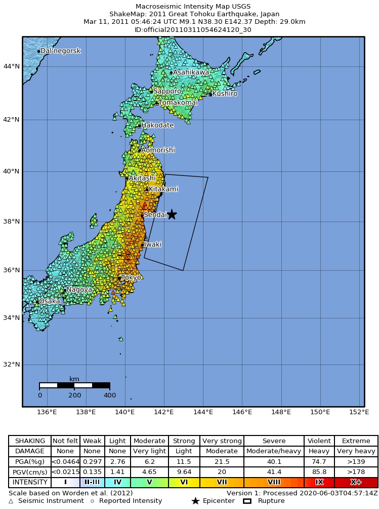
When Disaster Strikes
a GIX application
What is Disaster Management?
Ensuring communities are ready, resilient, and recover quickly.
-
Preparedness
Planning, training, and resource management to reduce disaster impact.
-
Response
Coordinated actions during a disaster to save lives and protect property.
-
Recovery & Mitigation
Rebuilding, learning from events, and reducing risk for the future.
-
Resilience Planning
Designing communities and infrastructure to withstand, adapt, and bounce back faster from disasters.
GIX in Disaster Management
-
GIS: Mapping Risk and Response
Geographic Information Systems (GIS) analyze and visualize spatial data to identify hazard zones, vulnerable populations, and critical infrastructure. During disasters, it supports real-time mapping for coordinated response and resource deployment.
-
Geospatial Intelligence: From Data to Action
Geospatial Intelligence transforms satellite imagery, sensor data, and field reports into actionable insights. It enables decision-makers to prioritize evacuations, allocate emergency services, and anticipate cascading impacts.
-
Applied in Global Emergency Operations
GIS and Remote Sensing are used worldwide for disaster preparedness, response, and recovery. From flood forecasting to wildfire monitoring and earthquake damage assessment, spatial intelligence strengthens resilience at every stage.
Remote Sensing in Disaster Management
-
Satellite imagery detects
floods & wildfiresSatellite sensors capture large-scale images of disaster zones in near real-time. This allows authorities to quickly identify affected areas and plan emergency response efficiently.
-
Drones provide real-time
damage assessmentDrones can fly over disaster-hit zones to collect high-resolution images and videos. This helps teams assess structural damage, road accessibility, and areas needing urgent aid.
-
Monitoring change
before & after disasterComparing images over time reveals how landscapes and communities are affected. It supports recovery planning and helps evaluate the effectiveness of mitigation strategies.
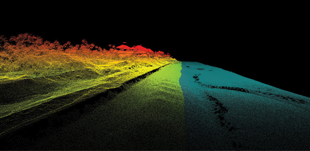
LiDAR in Disaster Management
-
Laser-based 3D mapping technology
LiDAR uses laser pulses to measure distances and create high-resolution 3D maps. It captures detailed information about terrain, vegetation, and man-made structures.
-
Measures terrain elevation precisely
Accurate elevation data helps model flood zones and landslide-prone areas. Planners can predict water flow, identify risk zones, and design mitigation strategies.
-
Identifies flood-prone and landslide-risk areas
3D maps highlight slopes, depressions, and vulnerable regions in fine detail. Authorities can use this information to prioritize infrastructure improvements and emergency planning.
GIX in Action
Map hazard zones
Identify high-risk areas using spatial data to guide preparedness and risk reduction strategies.
Model flood scenarios
Simulate water flow and impact under different rainfall and terrain conditions to anticipate potential damage.
Plan evacuation routes
Analyze road networks and population distribution to design safe, efficient evacuation pathways.
Allocate emergency resources
Optimize the placement of personnel, shelters, and supplies to ensure rapid and equitable response.
Shaping the Future of Cities
Faster response time
Real-time geospatial data enables authorities to identify affected areas immediately after a disaster strikes. This shortens decision cycles and accelerates deployment of emergency teams and resources.
Reduced casualties
Accurate risk mapping and early warning systems help communities evacuate before hazards escalate. Better situational awareness allows responders to prioritize the most vulnerable populations.
Better infrastructure planning
Spatial analysis identifies high-risk zones where infrastructure must be reinforced or redesigned. Long-term planning reduces damage, recovery costs, and service disruption during future disasters.
Climate resilience strategies
Predictive models support adaptation planning for floods, heatwaves, and extreme weather events. Cities can implement proactive measures that strengthen resilience instead of reacting to repeated crises.